A mostrar 397–405 de 783 resultadosOrdenado por mais recentes
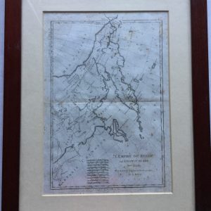
470-MAPA-GRAVURA ORIGINAL
€80,00470-MAPA- GRAVURA original- sec. XVIII- CERCA DE 1760
AN ACURATE MAP OF THE MARQUISATE OF MORAVIA
FROM THE SIEUR ROBERT: with improvements
ENGRAVED BY THE KINGS AUTHORITY
FOR THE NEW GEOGRAPHICAL DICTIONAIRY
LONGIT EAST FROM LONDON
G. ROLLOOS SCULP
MED.- 47,5 X 38 CM (moldura)
Printed area is approximately 28.5 by 19,5 cms
Guaranteed to be over 250 years old.
469-MAPA- GRAVURA ORIGINAL
€80,00469-MAPA- GRAVURA ORIGINAL
LA CORINTHIE,LA SICYONIE,LA PHILIASIE,ET L´ACHALE.
POUR LE VOYAGE DU JEUNE ANACHARSIS
PAR BARBIÉ DU BOCAGE——JUIN 1786
LIVRE- VOYAGE- CHAP.XXXVIII
IN 4º TOME II P 349 , IN Sº TOME P. 108
PLANCHE Nº 16
MED:- moldura- 51 x 34 cm GRAV. -36 X 17 CM
Guaranteed to be over 250 years old.
A map of the ancient Greek coast of the Gulf of Corinth, Plate 16 from the 1788 edition of Barbie du Bocage’s Recueil de Cartes Geographiques Plans, Vues, et Medailles de l’Ancienne Grece, Reelatifs au Voyage du Jeune Anacharsis. The map depicts the northern Peloponnese regions of Corinthia and Achaea, with adjoining parts of the Megarid, Argolid, Arcadia, Elis, Aetolia, Locris, and Boeotia. Key cities and towns in the region, including Corinth, Argos, Sicyon, and Elis are illustrated as walled enclosures.
The Recueil de Cartes Geographiques Plans, Vues, et Medailles de l’Ancienne Grece, Reelatifs au Voyage du Jeune Anacharsis was an atlas published by the Paris booksellers, printmakers, and engravers Jean Denis Barbie du Bocage to accompany Jean-Jacques Barthelemy’s Voyage du jeune Anacharsis en Grèce dans le milieu du IVe siècle. The Voyage du jeune Anacharsis was an unusual work. Written as a sort of general guidebook to the cities, customs, and culture of classical Greece, it purported to be the work of the grandson of the Scythian philosopher Anacharsis, documenting his travels in Greece during the 4th century BC. This clever literary conceit allowed the real author, Barthelemy, to explore the history and society of Classical Greece in a manner that was informative, yet informal, aiming to appeal to a much broader audience than a traditional academic history. Barthelemy was a talented antiquarian, particularly in regards to the study of ancient numismatics, and although the content of his work contains numerous historical flaws, the Voyage du jeune Anacharsis was a huge success, appearing in numerous editions and reprints. Sadly Barthelemy received very little from his success, his aristocratic background marking him as a target for the Revolutionary government, who confiscated most of his wealth. Despite his economic hardships, the general public continued to hold him in high esteem, and the demand for his material on ancient Greece was the main motivation behind the publication in 1788 of the accompanying Atlas to the Voyage. The first edition of Barbie’s Recueil contained 31 plates related to Barthelemy’s text, including maps of cities and territories, plans of battles, religious sanctuaries, and public spaces, and illustrations of temples, theatres, and even coins.
Henri-Joseph Godin (1747-1834) was a French painter, engraver, and printmaker. He worked on maps for a number of atlases, as well as portraits, architectural plans, and antiquarian subjects.
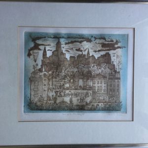
468-PRINT COLORIDA-NEW YORK FANTASY
€60,00468- NEW YORK FANTASY II
CAROLE TELLER
ORIGINAL ETCHING – 1982
PRINT SIGNED- 1/150
SELL BY GALLERY BRENTANOS- 3710/82
CAROLE TELLER (American, Late 20th Century) “NEW YORK FANTASY III”.
Print shows images of the past in New York City including buildings, people, etc. Pencil signed and titled and “Artist Proof”. Housed in a modern aluminum frame with white matte. SIZE: Sight: 9-3/4″ x 12-1/2″. CONDITION: Very good. 9-91534 (100-150)
Carole Teller, a Brooklyn-born artist who has lived in the East Village of New York City for over 50 years. Carole is also a photographer with a keen and prescient eye, capturing in her daily travels places that struck her, but which were also often on the precipice of change or disappearing. In some cases these were buildings in the process of being demolished, like Penn Station or tenements being cleared for urban renewal. From the early 1960s to the early 1990s – a period during which New York underwent incredible change, and has since undergone further dramatic change – Carole captures the poignancy and beauty of a city in flux. While she focused largely on her downtown surroundings, she captured Brooklyn, Midtown, and other locations as they experienced the sometimes jarring ebb and flow of time.
MED:- 52 X 41, com moldura